Yesterday’s post now has photos.
One of the appeals of Toyoko Inn is that aside from small variations in building shape and size, each one is pretty much exactly the same. You know exactly what you’re going to get. Rooms are identical, and so forth. The one here in Nagoya has a few differences. First, we noticed the bedspreads are a different colour, the bedside table is built into the wall instead of separate, the chair at the desk is a stool, the beds don’t have a sheet under the bedspread. Then we noticed the most major difference: the shower in the bathroom usually has just a nozzle-on-a-hose doobie, but this one also has a rain-type shower head fixed in the ceiling, with a lever to switch flow between them.
Today started with breakfast in the huge new Toyoko Inn’s humungous breakfast room. Rows and rows of rice balls, piles of sides, trays of bread.


Nagoya, incidentally, is the capital and largest city in Aichi Prefecture. Actually, it kinda seems like the only place we’re staying that’s neither the capital nor the largest cities of their respective prefectures was Chigasaki. Nagoya is also the third-largest city in Japan, after Yokohama and Osaka (recall, Tokyo is not officially designated a city). 2.28 million people live here. It was largely built up during the Tokugawa Shogunate as a castle post town on the Tokaido road.
But anyway, then it was time to head out today’s activity, hiking. We decided to get the hotel’s shuttle bus back to the station, but I’d forgotten I’d spotted a couple of places that looked worth revisiting on our walk here last night. Oh well. As per the iPhone weather forecast, it was lovely and sunny all day long.
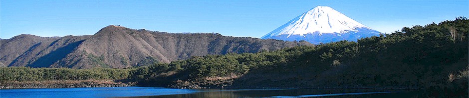
Like yesterday’s activity, this is going to require a bit of exposition. Back in Edo Period Japan, when the Shogun controlled power in the country, part of his brilliant strategy for retaining that power was requiring that all nobles spend half the year living in their own territory, and half the year living in Edo, the capital. As part of this, several routes were designated official highways. Two of these routes connect Edo with Kyoto: the Tokaido, the Eastern Sea Road, which runs along the coastline (and now lends its name to the Tokaido main line and shinkansen), and the Nakasendo, the Middle Mountain Road, which (as you might be able to tell from the name, runs through the mountains).
To facilitate travel, post towns were set up along each route as places where nobles and their attendants could stop for the night. Today, we walked part of the Nakasendo which still exists, between two post towns that have been restored to their appearances as Edo-period towns: specifically, from Magome-juku in Gifu Prefecture to Tsumago-juku in Nagano Prefecture, respectively the forty-third and forty-second of the sixty-nine Nakasendo post towns. Both in the Kiso Valley. It’s the most popular section of the Nakasendo for tourists today.
Getting to the start of our walk involved getting back on the Shinano Express for our second time in two days, but this time hopping off at Nakatsugawa Station and catching the bus for Magome. I noticed quite a few foreigners around the place two days ago in Kanazawa, though barely any yesterday on the Alpine Route, but today our bus was absolutely packed with westerners. Several of whom had never been trained on how bus ticketing works in Japan.


In any case, after a short ride, we arrived at Magome. It was quite a nice little town, though quite steeply sloped. I kinda almost feel like I could spend an extended relaxation type holiday there. One thing that amused me was the big direction signpost pointing up the road to Edo (rather than Tokyo).


It was a bit too early for lunch, so we decided to grab some snacks to tide us over – some Gohei mochi, the local specialty consisting of white rice pounded into a sticky cake, stuck on a skewer, coated in a sweet sauce and aromatically cooked over a flame. James needed to break a ten-thousand-yen note too, so he decided to buy some snacks from the local convenience store (modern convenience store on the inside, Edo-period building on the outside).


Then we set off on our walk. The total walk is about eight kilometres long – the path runs uphill for the first third of the way until Magome Pass, then it runs downhill all the way to Tsumago. It was a very nice walk, winding through the forest, and occasionally cutting across the modern roads, though the uphill section certainly took a lot of puff. As well as being the top of the walk, Magome Pass also represents the border between Gifu and Nagano Prefectures, making this the first time I’ve ever walked across a prefectural border.


Shortly after cresting the path, we came across a rest house surrounded by cherry trees. The proprietor called us inside, and we found ourselves drinking tea with two couples who were also from Australia – one from Melbourne and one from Sydney. As we finished drinking, more Australians turned up – a family from Sydney, and another one from Adelaide. Guess this place is popular for Aussies.


We continued on our merry way, at long last arriving in Tsumago. We only just managed to arrive shortly before the sun stated setting behind the mountains, and with only one more bus due to come before they stopped for the day. Tragically, far too late to get any lunch, but we managed to find a place open selling steamed buns. Once again my inability to judge how long an activity will take place rears its ugly head.


We sightsaw around Tsumago for a bit, including Kotokuji, a temple built above the town which has Japan’s first human-drawn cart hanging from the ceiling in a side hall. Soon, however, it was time to go and catch the last bus for the day back to the train station, this time Nagiso Station.


I was expecting to have to catch the local train back to Nagano, but it turned out that of the few Shinano trains that stop in Nagiso each day, one was due to do so in a couple of minutes, so we hustled to the correct platform to catch it. Sadly, had to make do with unreserved seats, as there was no station attendant present in Nagiso to reserve them from.


We arrived back at Nagoya after dark. I’d originally had an evening activity planned, but decided to give it a pass this time, since by the time we could have gotten there, there would only be an hour left until it closed. So instead we had dinner at a shop selling tempura. We had a six-piece chef’s recommendation platter – containing prawn, sand groper, baby corn, asparagus (we think), pumpkin and conger eel – then followed it up with a satsuma sweet potato, which took close to an hour to prepare. Tasty, though.


Finished off the night by getting the shuttle bus back to the hotel and getting some washing done. Sadly, though I’d been hoping to watch VS Arashi on TV, I completely missed it tonight…
Photos will have to wait, again. It was already 11pm by the time I started this.
Today’s photo count: Seven hundred and seventy-one. Used my third battery for the first time this trip, and also rolled over the next ten-thousand-photo tick in my camera.
Today’s step count: 17,218 steps, for 12.9km.
Today’s goshuin count: One – Kotokuji. And I just noticed I haven’t been posting images of my goshuin as I usually do…
Today’s stamp count: Zip. Seems like stations in this part of the country just don’t have stamps, and oddly there didn’t seem to be any on the Nakasendo either.